
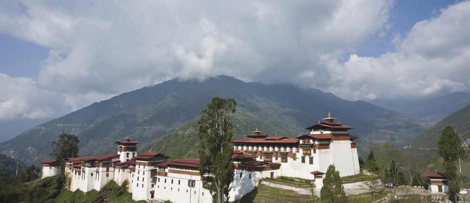
This commanding dzong, high above the roaring Mangde Chhu, is perhaps the most spectacularly sited dzong in Bhutan, with a sheer drop to the south that often just disappears into cloud and mist. The rambling assemblage of buildings that comprises the dzong trails down the ridge and is connected by a succession of alley-like corridors, wide stone stairs and beautiful paved courtyards. The southernmost part of the dzong, Chorten Lhakhang, is the location of the first hermitage, built in 1543.
The first construction on the site was carried out by Ngagi Wangchuck (1517–54), the great-grandfather of Zhabdrung Ngawang Namgyal. He came to Trongsa in 1541 and built a tshamkhang (small meditation room) after discovering self-manifested hoof prints belonging to the horse of the protector deity Pelden Lhamo. Trongsa (‘New Village’ in the local dialect) gets its name from the retreats, temples and hermit residences that soon grew up around the chapel. The dzong was built in its present form in 1644 by Chhogyel Mingyur Tenpa, the official who was sent by the Zhabdrung to bring eastern Bhutan under central control. It was then enlarged at the end of the 17th century by the desi,Tenzin Rabgye. Its official name is Chhoekhor Raptentse Dzong, and it is also known by its short name of Choetse Dzong. The dzong was severely damaged in the 1897 earthquake, and repairs were carried out by the penlop of Trongsa, Jigme Namgyal, father of Bhutan’s first king.
Trongsa Dzong is closely connected to the royal family. The first two hereditary kings ruled from this dzong, and tradition still dictates that the crown prince serve as Trongsa penlop before acceding to the throne.
The dzong’s strategic location gave it great power over this part of the country. The only trail between eastern and western Bhutan still leads straight through Trongsa and used to run directly through the dzong itself. This gave the Trongsa penlop enviable control over east–west trade and the considerable tax revenue to be derived from it. Today most visitors enter through the main eastern gate, but energetic types can make the steep cardio hike on the Mangdue Foot Trail from the viewpoint and enter the dzong via the western gate, in traditional fashion.
The Trongsa rabdey (district monk body) migrates between winter (Trongsa) and summer (Bumthang) residences, just as the main dratshang (central monk body) does between Thimphu and Punakha.
There are 23 separate lhakhangs in the dzong, though what you get to see depends on which keys are available. Most of the existing fine decoration was designed during the rule of the first king, Ugyen Wangchuck. To the side of the dzong is the archery ground and pavilion where the current king (then crown prince) was crowned penlop in 2004.
Rooms to visit include the atmospheric northern kunrey (assembly hall) and the impressive next-door Jampa Lhakhang, with a two-storey Maitreya (Jampa) statue. The southern Mithrub Lhakhang houses the funerary chorten of Ngagi Wangchuck. Feel for the footprints worn into the wooden floor by one overly enthusiastic prostrator.
The five-day Trongsa tsechu is held in the northern courtyard in December or January and culminates in the unveiling of a thondrol (a giant thangka – a painted or embroidered religious picture).
This is a bustling little one-street town in Bumthang with an abundance of restaurants and handicrafts stores. Jakar sells a good amount of chugo, a hard, chewy dried cheese snack popular among Bhutanese. Internet cafés and espresso bars have also started to make an appearance here.
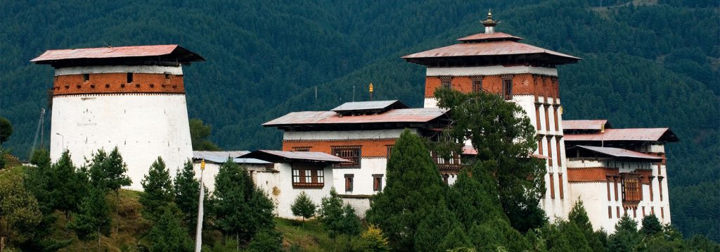
The Jakar Dzong or the “Castle of the White Bird” dominates the Chamkhar valley and overlooks the town. Constructed in 1549, by the Tibetan Lam Nagi Wangchuk, the Dzong played an important role as the fortress of defence of the whole eastern Dzongkhags. It also became the seat of the first king of Bhutan.
A special feature of the Dzong is the approximately fifty meters high Utse or the Central tower, which is distinct from most other Dzongs in Bhutan. The other unique feature of the Dzong is a sheltered passage, with two parallel walls, interconnected by fortified towers, which gave the population of the fortress access to water in the case of a siege. The protected water supply is still intact to this day.
Description
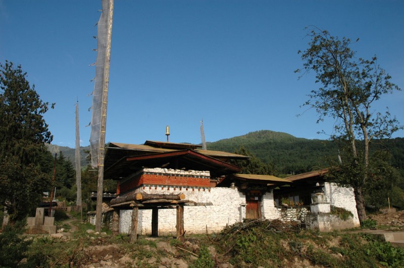
4 kms north of the headquarter, Konchogsum Lhakhang is located on the left bank of the Chamkhar river opposite Kuje complex and very close to Tamshing temple. This tiny temple is surrounded by an enclosure. Like any ancient temple in the Tibetan cultural area, the sanctuary consists of a small central shrine which may have had a circumambulation path.
History
Konchogsum Lhakhang (called Tsilung or Choekhor in the texts) dates, according to the saint Pema Lingpa, as far back as the 8th century. The temple is supposed to have been built by the Tibetan king Trisong Detsen after receiving instructions fromGuru Rinpoche to do so. The king sent one Bami Trisher from central Tibet to supervise the construction and Guru Rinpoche himself is said to have designed and consecrated the temple. However another Bhutanese tradition considers that it is one of the temples founded by the Tibetan king Songtsen Gampo in the 7th century.
In 1039 Bonpo Dragtshel, the first active terton (‘discoverer of religious Treasures’) in Bhutan, discovered texts which had been hidden by Guru Rinpoche at this spot. It is said that the king of the water deities rose out of the lake beneath the temple and offered Bonpo Dragtshel a stone pillar and a stone scroll.
Another story in the oral tradition claims that the saint Pema Lingpa in the 15th century also discovered religious treasures here, which he found in an underground lake. He then sealed up the entrance with a block of stone and set his lotus seal on it. Both can be seen in the courtyard. Following a prophecy to repair the temple, Pema Lingpa undertook the renovation of Chokhor Lhakhang in 1479. He mobilized the people of the valley to work on the project and invited an artist called Kungawo from Lhodrak, who restored the paintings. To fund the project, Pema Lingpa was told in a prophecy to extract gold from behind the Vairocana statue. This, he did in public only to reveal a thumb size wax figure of a donkey. However, the next day he found two tiny pieces of gold hidden in the wax donkey which miraculously turned out to be sufficient for gilding all statues and murals. The restoration took two years.
Several great visitors came to the temple, one of them being the Tibetan Dzogchen master Sogdogpa Lodro Gyaltsen (1552-1624). He noted that the locals call this temple Konchogsum Lhakhang “The three jewels” for its three main statues. The temple was gutted by a fire caused by a butter-lamp in February 2010 but the statues were saved.
Architectural style / school and related art works
This temple is famous for its ancient relic, a bronze bell (choedril), which bears an inscription from the eighth century on the inside. The chimes could be heard all the way to Tibet. The Tibetan army was sent to get it but the bell was so heavy that the soldiers could not lift it and they let it fall, which explains why it is broken. The bell remained in Bhutan.
As for the pillar which stands in front of the enclosure, it is probably an ancient megalith. Megaliths are very common in Bhutan and especially in this region. The main statues in the sanctuary are the Buddha Vairocana, which seems to point to the antiquity of the temple, Guru Rinpoche and Avalokiteshvara. There are also statues of the great Nyingmapa masters of the Dzogchen tradition: Pema Lingpa and Longchen Rabjam (14th c.). On the walls there were paintings of Guru Rinpoche as well as Pema Lingpa, Longchen Rabjam and Jigme Lingpa (18th c.).
Social cultural function
The temple is an important historical place for the Bhutanese and it is also a place of worship for the villagers in its vicinity. It is looked after by a caretaker of the next by Tamshing monastic community. A school for young monks has been built in 2009 next to the temple and is attached to Tamshing monastic community which upholds the religious teachings of Pema Lingpa (1450-1505).
Built in 1501 and located 5km away from Jakar town in Bumthang.
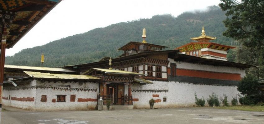
Tamshing monastery originally known as Tamshing Lhendup Chholing (monastery of good message), is located in Chokhor valley at 5km distance from Jakar town. It is a small single storey complex surrounded by village houses and a magnificent view of the Kurjey Lhakhang on the opposite side of the Chamkhar River.
History
The monastery was built in 1501 by the Pema Lingpa himself. Pema Lingpa is a great Buddhist saint and spiritual master who discovered many treasures around the kingdom. He built the monastery with the help of Dakinis who built a lot of statues. Pema Lingpa is also credited with the founding of various sacred masked dances.
Architecture
The entrance is led by a long pathway to the monastery which goes through an inner courtyard with monk quarters to its side and a huge prayer wheel to its left. The monastery with its unique interior design has the main altar built as a separate structure in the center of the ground floor of the main temple. In the alter, there are three main seats specifically designed for the three incarnations (body, mind, and speech) of Pema Lingpa. On the inner walls of the temple, there are images originally painted by Pema Lingpa himself which have not been restored since it was first painted. Though there is said to be even older paintings underneath.
The temple houses statues of Guru Rinpoche with a statue of Jampa (Buddha of the future) and Sakyamuni to its sides. The statue of Guru Rinpoche is said to be the primary statue of the temple. The most astounding aspect of the statue is that it was sculpted by the Dakinis and it is said that the eyes of the statue are looking upwards to look at the Dakinis ascending into the sky. A balcony spreads around the on the top floor of the temple. The balcony has a low ceiling as it is said that Pema Lingpa built the balcony to his exact size and Pema Lingpa was short in height. The balcony houses old religious paintings and various masks carved by Pema Lingpa which are off-limits to visitors.
The temple itself is built one above the other with a narrow path which runs around the main altar of the temple for circumambulation.
Pilgrims are advised to circumambulate around the alter carrying an iron blanket which was weaved by Terton Pema Lingpa himself when he was 8 years old which weighs around 20kilograms and it is believed that if one circumambulates carrying the iron blanket is said to rid them of their sins and bad intentions.
Events
The monastery currently houses about 100 monks. Every year a festival called Phala Choedpa is observed in the courtyard of the monastery. A series of unique ceremonial dances as part of the tradition set by Pema Lingpa himself is also performed for 3 days on the 8th Bhutanese month. Tamshing monastery also acts as a place of daily worship for villagers.
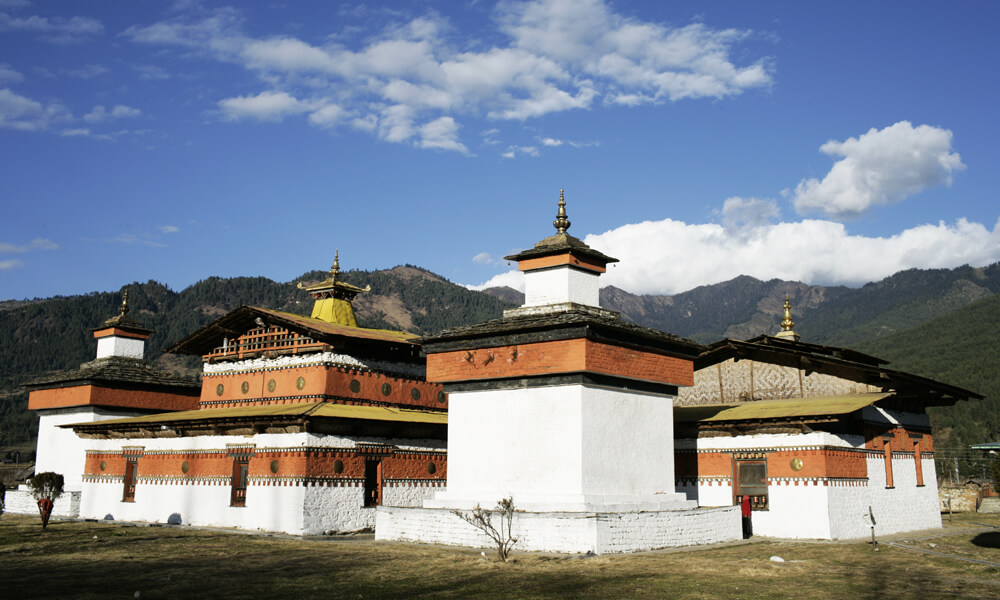
Jampey Lhakhang is said to be one of the 108 temples built by the Tibetan King Srongtsen Gampo in 659AD . This temple was built on a single day by subduing the demoness which was said to have been causing obstruction to the spread of Buddhism. Temples were built over her body parts that spread over Tibet, Bhutan and the borderlands. The best known temples are Jorkhang in Lhasa, Kichu in Paro and Jambay Lakhang in Bumthang. Kongchugsum in Bumthang, Khaine in Lhuentse and the two temples of Haa might have also been the parts of these 108 temples. This temple was later visited by Guru Rimpoche and was restored by Sindhu Raja after Guru Rimpoche cured of his illness. Since then this temple has been repaired and rebuilt several times. This is a must visit sight in Bumthang.
Area and Location of Royal Manas Park
Royal Manas National Park is the oldest National Park situated in the south central foothills of Bhutan (90°35’ E to 91°13’E and 26° 46’N to 27° 08’N). Spanning an area of 1057 km2, the national park falls within the political jurisdiction of three Dzongkhags i.e.,Zhemgang, Sarpang and Pemagatshel. The national park can be accessed from Bhutan, and the Indian state of Assam.
Connected by the biological corridors to Jigme Singye Wangchuk National Park in the northwest, Phibsoo Wildlife Sanctuary in the southwest, Phrumsengla National Park in the northern center, Jomotshangkha Wildlife Sanctuary in the south east, the location of Royal Manas National Park is notably outstanding and forms the cornerstone of protected area network in Bhutan. Further the national park abuts with Indian Manas National Park in the south, forming a significant part of Transboundary Manas Conservation Area (TraMCA) for promoting landscape level ecosystem management.
Edged against the magnificent emerald Manas River, the national park is arguably an oasis filled with remarkable diverse floral and faunal assemblage. Dense towering mountains punctuated with rivers and small streams invariably characterize the park. The park habitat includes extensive areas of tropical monsoon forest interspersed with swathes of natural grasslands and wide river-beds along the southern border. The lowest hills of park are clothed in tropical moist forest, which gives way temperate broadleaf forests in the higher elevations. A dense oak forest dominate the higher ridges.

Management History and Evolution of Management Plan
The Royal Manas National Park is the earliest addition to the protected area network in Bhutan. It started as a game sanctuary and was later notified as Manas Wildlife Sanctuary in 1964.In the year 1993, it was upgraded and constituted as Royal Manas National Park through mergence of Namgyel Wangchuck Reserve and Manas Wildlife Sanctuary. The first conservation management plan was enacted for the period from 1995-2000 chiefly prioritizing on infrastructure and human resource development. The paucity of scientific studies and other socio economic activities were mainly due to the lack of technical competency and political upheaval, which prevailed along the neighboring country. Over the years, there has been a paradigm shift in the management of park recourses giving prominence to scientific core management based on park zonation. The use of cutting edge scientific tools such as the non-invasive camera trap method in studying the ecology of the big cat species has been a key feature in linking research to on ground conservation activities. Anti-poaching and socio-economic activities, habitat management and communication facilities were also up scaled in the second management plan period from 2009-2014.
Conservation Significance
Located at the convergence of the Indo-Gangetic and Indo-Malayan bio-geographical realm, the Royal Manas National Park forms a part of the ten global biodiversity hotspots constituting remarkably a diverse and rich ecosystem of international significance. The national park is the central thread that connects other protected areas in Bhutan and further adjoins with the World Heritage Site (Manas National Park) in India forming an integral part of TransboundaryManas Conservation Area (TraMCA).The region forms an indispensable corridor for the Terai-Arc tiger Conservation Complex between Terai regions of Nepal and India with landscapes in northeastern India, Myanmar and Southeast Asia. The significance of the entire Manas landscape as a single Transboundary entity and as conservation complex is acknowledged globally by no less than the UNESCO World Heritage Centre, Paris (Borah et al.2012).This conservation complex is also identified as one of the important Tiger Conservation Landscape (TCL) #37(Namdapha National Park- Royal Manas National Park) for the long-term survival of tigers in the wild (Sanderson et al. 2006).
The unique landscape of RMNP forms an important natural conservatory of the country representing outstanding habitat diversity ranging from tropical monsoon forests (< 500m) and subtropical forests (500-1000m) to warm broadleaved forests (1000 m-2000m) and cool broadleaved forests (2000m-2714m). The park owes its name and also much of the spectacular grandeur from the life giving ´Manas river`. The river Manas forms the lifeline of RMNP providing a large track of highly significant watershed area. Emerging from the convergence of Drangme Chhu and Mangde Chhu, the Manas river is one of the largest Himalayan tributaries of the mighty Brahmaputra river.
The national park is home to two endemic and globally threatened species viz. golden langur and pygmy hog. It is one of the few places in the world to harbor highest felid diversity of 8 species of which 5 species are listed in red list of IUCN. Renowned for its spectacular landscape suffused with one of the highest diversity of species in the country, it provides a safe refuge for charismatic species, which are endangered such as the Royal Bengal tiger, golden langur, clouded leopard, Asian elephant, Asiatic water buffalo, dhole and Asiatic gaur. RMNP is now increasing acknowledged as an important source population of Royal Bengal Tiger and their conservation now requires, more than ever before, informed conservation interventions guided by sound ecological knowledge.
Biodiversity Richness
RMNP is famed for harboring one of the greatest populace of wildlife diversity. The park has 558 species of flora, 65 species of mammals, 489 species of birds, 60 species of fishes and more than 180 species of butterfly species recorded till date. Out of the 65 mammal species recorded, 2 species are critically endangered, 8 species are endangered, 9 species are near threatened and 11 species belong to vulnerable list. Species from 8 orders belong to IUCN Red List.
Known as the paradise for birdlife, Royal Manas National Park has an incredibly high diversity of avifauna with a record of 489 species listed till date (April 2016). Within an area of 1057 sq. km, more than 70% of bird species found in Bhutan are present in RMNP. The extraordinarily rich bird diversity is mainly attributed to existence of vast areas of relatively undisturbed natural habitats, with swathes of savannah grasslands to vast expanses of old growth tropical and subtropical and temperate forests along wide altitudinal range. The park is home to three species of critically endangered species, White-bellied Heron (Ardea insignis), White-rumped Vulture (Gyps bengalensis) and Red-headed Vulture (Sarcogyps calvus), five species of Near Threatened, and six species are Vulnerable (Tragopan satyr) (Indicator xanthonotus) (Buceros bicornis) (Speclaeornis caudatus) and (Alcerdo Hercules) in the IUCN redlist of threatened species. It is one of the few protected areas in Bhutan, providing a safe refuge for all the four hornbill species.
The national park is also home to globally rare and endangered floral species such as Dalbergia oleveri ( IUCN endangered species), Aquilaria malaccensis (IUCN vulnerable) species) and Taxus baccata (Scheduled 1 species in FNCA 1995) and Podocarpus neriifolia the only conifer broadleaved tree found rarely distributed in the park area. The rapid assessment of herpetofauna diversity survey conducted along the fringe areas of Royal Manas National Park showed an addition of 8 new species. The Assam day gecko, Cnemaspsis assamnesis, which was recorded in the park, is known to be one of the rarest gecko so far known only from Northeast India.
Climate and Vegetation
Royal Manas National Park has a moist subtropical to cool temperate climate with four distinct seasons. Summer lasts from May to August with annual maximum temperature ranging from 20oC to 40oC. The rainfall ranges from 200mm to 4400 mm annually. Autumn lasts between September and November experiencing changeable weather, which gradually takes on the shape of winter pattern. Characterized by cool weather and fog, winter is relatively drier with rare shower and average temperature ranges from 5oC to 20oC.The park experiences strong to moderately strong wind in the months of February- April.
The forest types of Royal Manas National Park are broadly classified into four eco-floristic zones such as Tropical monsoon forests (< 500 m), Sub-tropical forests (500 -1000 m), Warm broadleaved forests (1000 – 2000 m) and Cool broadleaved forests (2000-2714 m) (Wangchuk 2009).
Geology, Rock and Soil
The geology of RMNP consists mostly of Buxa formation characterized of dolomites, quartzite, variegated phyllite, overlain by Manas formation and Shumar formation characterized of meta sedimentary phyllite, quartzite and thin calcareous bands containing dolomite and limestone bed rocks (Sherub and Wangchuk 2006). The southern part of the park consists of bhabar tract containing sandstone, limestone and shale. Bhabar tract formation is very porous due to the deep deposits of coarse detritus overlain by sandy loam and a thin layer of humus. Alluvial and colluvial formation result from slow erosion of rock from the northern area of the park stemming as a result of heavy rainfall during monsoon. The alluvial formation is distinguished by mixture of boulders and sand, covered by debris, sand, soil, silt and clay brought down by the rivers.
Hydrology and Water Sources
Royal Manas National Park abounds with perennial rivers and transitory streams and rivers formed during the peak monsoon season. The largest river of the country, Manas drains about two third volume of the water of the country. It springs from four major tributaries viz. Mangde Chhu, Chamkar Chhu, Kuri Chhu and Drangme Chhu in eastern and central Bhutan. The other perennial rivers such as Udigang, Kukulung and Kanamakura river forms some of the important watersheds of RMNP. Waterholes and mineral licks form an integral part of functioning ecosystem. Waterholes and saltlicks are erratically distributed with higher density along the foothill belt of the park.
Park Management Zones
In the first Conservation Management Plan five management zones were categorized in the year 1995-2000 depending on the various land-use types and human settlements. The park zonation was later reformed into three zones namely core zone, multiple use zone and buffer zone in 2012 to achieve the vision and management objectives of RMNP.
